Stewart Island circumnavigation attempt 2020
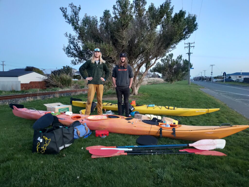
In the winter of 2020, my friend Harry and I were sitting in his truck eating some pies when he asks me, “do you want to kayak around Stewart Island?” I said “yes, one day”. He then asked if we should start in 2 weeks’ time. We were both seasonal guides and had the full winter off work. As we had nothing planned, we decided to go for it. Stewart Island is New Zealand’s 3rd largest island located in the deep south below the South Island. Over 12 days we kayaked 110km into Port Pegasus, before the absolute weather bomb hit.
Getting organized
With only 2 weeks to plan we had to hurry. We needed to organize kayaking gear, logistics, food, comms and look at the weather. Luckily at the time I was kayak guiding in Fiordland, easy access to all the kayaking gear we needed while the company was on break for the winter. Harry had a kayak in Glenorchy that we had to go and pick up – about an hour’s drive from Queenstown.
Once we had collected all of our equipment, it was down to Invercargill to finalize everything. A quick stop in at Backcountry Meals who were kind enough to give a major discount for a bulk order. Then to PacknSave – A New Zealand supermarket to buy all of the extra food we would need for the trip. We planned on fishing along the way for the majority as this would save us money and provide good eating and protein. After purchasing all of our extra food and supplies it was all ready to go.
We decided to do a dry pack of all the gear into our kayaks the day before to make sure everything fit well. Luckily it all went in nice and easy for us. It was then to bed to get a good sleep for the start day tomorrow.
Early start and we were off to Bluff to catch the ferry down to Stewart Island. While waiting for the ferry we had a quick chat to the Lady who is in charge of all the fishing boats and marine activity in the area, she told us the radio channels and times for weather updates and also told us that a 6m Great White shark was spotted a week ago on the island. We knew Stewart Island was a breeding ground for these sharks, but it just made it extra terrifying knowing there was a 6m Great White Shark hanging around.
Oban is the only township in Sewart Island, and our finish point of the boat ride. Once we got off the ferry, it was multiple trips back and forward from the dock to the beach – approximately 400m each time, to bring the kayaks and equipment down. A quick pie from the shop and away we went.
Day 1
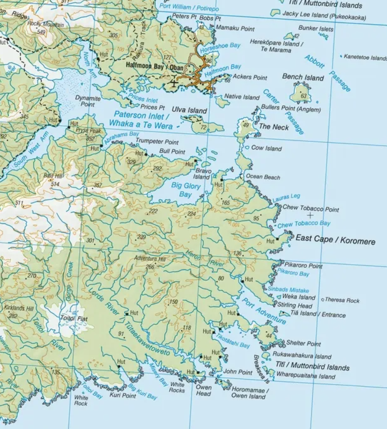
It was already after lunch by the time we got on the water, so we knew we weren’t going to make it very far. Ocean beach was the target, roughly 14km of paddling. It was pretty easy conditions but, the kayaks were extremely heavy, this was the biggest trip I had done so far. We packed for about 40 days of food and gear. Before dark we arrived at Ocean Beach. Enough time to get the last rays of sunshine to dry the gear out.
Day 2
Our aim for day 2 was to make it to Chew Tobacco Bay. Roughly 7km from our current location. As we had to time restraints and just wanted to be out on an adventure as long as we could, we did schedule in some smaller days and side missions along the way. As we woke up, we could hear the swell crashing into the beach, 2m swell was the forecast for today. Nothing like starting your day paddling through decent sized crashing waves in the middle of winter. Soaked already we made it out past the crashing waves and into the calmer waters, around the point and into Chew Tobacco Bay which had a lovely hut for us to use.
Day 3
Getting around the east cape was the goal and hopefully into Port Adventure. With similar conditions to day 2 we made our way out, the swell and wind increasing slightly as we neared the cape. Very confused waters but with a nice tail wind to help us through. We made into Port Adventure and went straight to the hunter’s hut; it was a very cold hut being situated in the shade for most of winter. Kelly’s hut was just across the bay in the sunshine; we quickly decided to make our way over to that hut instead. As soon as we came out of the shade we knew we made the right call. All up about 14km for day 3.
Day 4
We woke up to glass conditions, as we paddled further the weather deteriorated. 2m swell and 20 knot winds around the point of the Mutton-bird Islands kept us moving pretty fast. We made our way into Little Kuri Bay for the night. A lovely little bay with a hut that has the exact same layout as the previous huts.
Day 5
We made our way out of Little Kuri Bay, around the point into a place called Lord’s river. This area was well known for the beautiful flat-water river that you can paddle or boat up against the flow. We made our way to the hut at the entrance to the river and fully unloaded the kayaks. With empty kayaks we made our way up Lord’s river, a pleasant change paddling with very little weight in the kayaks. It was still a challenging paddle going against the constant but slow flow of the river, but well worth it as the area was stunning, thick shrubs with overhanging Rimu trees and plenty of birdlife. We kayaked all the way up to the hut for a look around, swapped some books over and made our way back out. The return journey went much faster with the flow behind us. During the evening weather forecast we heard that the weather was getting much worse.
Day 6
We left Lord’s river area and set of for Big Kuri Bay. Already noticing the weather worsening. Instead of 2m swell and 20 ish knots of wind, we were getting 2.5m swell and 25-30 knots. Luckily all tail wind which had been helping us down the coast most of the way. The sea was very choppy and confused, we had to be on to it and not loose concentration at all during the paddle to Big Kuri Bay. Everything went well and we arrived with plenty of time to dry some gear out.
Day 7
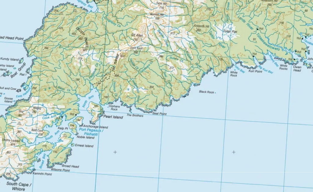
This was an interesting morning, as we were getting our kayaks loaded up beside the hut, we noticed a baby sea lion making it way along the beach just next to the shoreline. When we decided that we were ready to carry the kayaks down to the water the sea lion would charge at us from a distance. For about an hour we were trying to get to the water without disturbing this baby sea lion. Eventually it decided to head off in a different direction which allowed us to get on the water much later that planned though. This was our ‘Big’ day of paddling. There was no realistic chance of landing for about 30km. This was also going to be our only weather window for a distance like this for the next 2 weeks according to the forecast. We had to paddle hard and fast to get to Port Pegasus. On our way down the weather wasn’t too extreme, just similar to what we had been seeing the last couple of days. Until we got down to ‘The Brothers’. These are 2 islands that funnel the swell into Whale Passage. Everything looked manageable as we were paddling into Whale Passage until we noticed big crashing waves Infront of us, it was too late to turn around or find another way. We had to paddle with these huge crashing waves. Harry ended up having a scary surf, he was nose down on a wave barely managing to keep it upright for about 100m. Luckily, I didn’t end up getting surfed badly at all. Once we were past the brothers it went to flat and calm immediately. We took a moment to just chill and try to figure out what just happened. The paddle to the next hut was very easy from here, flat water and zero wind. We did some fishing, caught a bunch of blue cod for dinner and made our way to the hut.
Day 8
Weather forecast was horrific. We had no choice but to stay in Port Pegasus for at least 5 days from the last forecast. Luckily this area is full of separate adventures close by. It was still windy, but we were easily able to paddle within the sheltered area. Our first day plan was to go to the ‘Tin Range’ which was the walking track into Port Pegasus from the famous Southern Circuit trail. This track was formed to allow prospectors to head into Port Pegasus to look for tin and small amounts of gold. As we left our hut, we noticed in the distance about 50knots of southerly winds along the far side towards the Tin Range. We changed our plan and headed towards Bald Cone. A beautiful viewpoint with an exposed granite dome top. Getting past the scrub was very difficult, it was extremely dense, neck high and full of stiff branches and spikey leaves that would do serious damage to clothing if not careful. Once we were past the scrub it there was nice muddy trail leading up to the top. A stunning view of the coastline while also witnessing how rough it actually was on the coast. Within about 10 min of reaching the summit we were greeted with sideways hail, so we made our way back down and back to hut.
Day 9
Our aim was to go and climb the mountain ‘Gog’. It started with a 5km paddle down the cook arm. During the first section of the paddle, we had a visit to the southern Port Pegasus hunter’s hut. There was a group of fisherman and hunters staying there for a week. We had a quick chat about what we were doing, they kindly offered us a ride out with them if we needed it, as they were well aware of the forecast. We then made our way up cook arm. Once we got to the end of the arm, we stashed our kayaks in the bush and proceeded to walk through some more neck height scrub. We eventually found a decent path to follow through the scrub which made it 10x easier to walk through. Once at the base of Gog, it was easy walking up granite rock to the top, some sections were wet and slippery, but the majority was dry enough. At the top were immediately blasted with huge winds as soon as came out of the cover of the mountain. It would have been about 70+knots. We took shelter behind a large boulder through the worst of it. Eventually it eased so that we could take a look at the southern side of Stewart Island. It was a very gloomy view. Super rugged coastline with plenty of small islands, huge crashing waves and unprotected from the wind. We instantly knew we would not be getting around the cape anytime soon with the forecast. Once we got back to the kayaks, the tide had fully dropped out on us. This meant we had to walk our kayaks for about 2km until the water was deep enough to paddle. As we began kayaking, we had a lovely 50 knot wind directly bind us which helped us get home to the hut nice and fast.
Day 10
Day 10 was just a day off in the hut, reading books and keeping the fire going. Trying to dry all of our kayaking gear and thermals above the fire was keeping us very busy. We had a couple of talks about our plan and remembered that the hunters were getting a ride out in 2 days’ time. Our plan was to go and visit them tomorrow to listen in to the long-range forecast, if it wasn’t easing up within a week, we would hitch a ride out.
Day 11
We had a chill morning just reading more books, Harry went for a quick hunt in the forest behind us, no luck though. After lunch we paddled over to the hunter’s hut. We talked for a while before someone said “forecast”. We listened in. The best day within the 20-day forecast was 4m swell and 40 knot winds. This easily made our mind up for us. We asked the hunters if they were still okay with giving us a rescue ride out. They were still happy to do so, they just asked that we meet them early tomorrow to help load the boat and pack their camp down. A small price to pay for a rescue ride out of there.
Day 12
We woke up at around 6am, we needed to fully pack our kayaks again for the first time in about 5 days, pack up the hut and give it all a good clean before meeting the hunters at 8am. We had to paddle against 35knot for a couple of kilometers with fully loaded boats to get there, one last challenge before we left. We then helped pack down the camp and load everything onto the 30ft catamaran. The boat was fully loaded with all of their supplies, 2 small Stabicraft boats and 2 sea kayaks. As we left Port Pegasus, we entered the coastline into 4m swell. Which ended up getting bigger and bigger as we made our way north. Apon nearing Oban we heard that ferries that transport the locals and tourists to and from Stewart Island don’t run in 4m+ swells. Once we were into the Foveaux Straight, we had 6m swell and 60 knots winds. This straight is notorious for being extremely rough as it is quite shallow water. The boat was getting bombarded with huge waves all around. Occasionally the skipper would yell out “HOLD ON”. It was by far the worst conditions I have encountered on a boat. Luckily, we made it safe and sound back to Bluff. Immediately on the phone to parents and loved ones to tell them we are alive and well.
Learnings
- Don’t always trust the forecast – before we set off the long-range forecast was pretty much perfect, no more than 2m swell and 15 knots of wind.
- Stewart island’s coastline is stunning – If you can manage to get down and get your hands on a boat it will be well worth it.
- Sometimes going the longer way is better than shortcuts – e.g. the brothers, we should have kept going and paddled down the main entrance of whale passage instead of sneaking through the brothers.
- It pays to be nice to people – if we didn’t go and say hi to the hunters, we would have had a much harder time getting out.
- Always take plenty of food and supplies for a trip like this – We could have waited the storm out if we needed to and had plenty of food, but we didn’t want to be stuck a hut for 2+ weeks.
Brody is an expedition athlete and adventure content creator based in Wānaka, New Zealand. With six years guiding in Fiordland and multi‑week missions across Patagonia, Stewart Island, and soon Antarctica, he specializes in cold‑water, remote‑environment expeditions. Through Remote Horizons, he shares real‑world gear insights, expedition planning advice, and storytelling from some of the wildest coastlines on the planet.